Once again, I flew with Kenny Price and Devin Bargainnier. This time I flew with Devin on Saturday and Kenny on Sunday.
Day 1 - Saturday, August 14, 2010
Devin and I decided that we would attempt to fly to Mount Whitney, and farther south if possible. It was not possible. Not only to fly farther south of Mount Whitney, but the day was not strong enough to even get there.
Although it was mid-August, there was still a surprising amount of snow in the Sierras.
We made our way to the south, down to Mammoth Lakes Ski Resort south of Mono Lake.
This is looking east. The large lake in the distance is Lake Crowley and Mammoth Lakes Airport is between it and the small lake, running parallel to HWY 395. Boundary Peak is the the white peak to the far east on the White Mountain Range (see last post).
This is Blood Mountain. Hmmm, I wonder why they call it that.
As we rounded Blood Mountain, another spectacular sight came into view (which happens every time I go down the Sierras!). A vein of gray granite infused into the red mountain at the right in the photo provided an interesting contrast.
Here it is as we got closer and following it to the west.
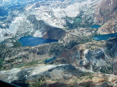
As we crossed the the next ridge, the most beautiful alpine lake I had ever seen came into view. It is Dorthy Lake. I thought I was seeing it for the first time. As I researched the name of this lake, I realized that I had seen it last year from a different perspective.
Dorothy Lake is at the bottom of this photo, and Lake Genevieve is to the upper left.
This is a photo from the first time I saw Dorothy Lake. It was last year, when I flew with Gavin Wills on my first ever trip to Mount Whitney during SoaringNV's first cross-country camp. This view is from much higher, and from the east looking west. Dorothy Lake is the large lake to the left and Lake Genevieve is the lake at the right of the photo. The smaller lakes above Lake Genevieve are Edith Lake and Cloverleaf Lake. This is my favorite soaring photo I have taken to date and serves as my desktop background.
We crossed a saddle in the granite infused mountain and then began a search for another "gas station". I had to remind Devin of the three rules of mountain flying!
We united with Mike Harrbison, a.k.a. "Mountain Mike" here and set-up for a photo opportunity. Mountain Mike is one of the most experienced fliers of the Sierras ever, and hence how he earned his nickname.
We continued together a little farther south, and then decided that we were not going to attempt Mount Whitney this day. We turned around and began the trip north back to Minden. Here we are at Tioga Pass (HWY 120), which leads out of Yosemite National Park and connects with HWY 395 near Mono Lake. The lake at the bottom of the photo is Ellery Lake and the lake at the top of the photo is Tioga Lake.
We continued north and found that the conditions were right to do something I had never done before. Fly into the Lake Tahoe basin. The big cumulus cloud in front of us would, in theory, provide us enough gas in the tank to venture over to Emerald Bay at the southwest corner of Lake Tahoe.
Here's a few shots of South Lake Tahoe as we are "filling up" before making the trip to Emerald Bay.
We actually flew farther west of Emerald Bay. These photos were taken as we returned to the "gas station" before we headed back to Minden.
Here's our flight trace from See You.
And here it is in Google Maps.
Day one totals: Flight time - 4.5 hours, Distance covered - 344 miles
Day 2 - Sunday, August 15, 2010
I didn't take any photos during this flight. Kenny and I flew down to the ghost town of Bodie, and then started towards Mount Grant. However, the cloud bases at Mount Grant were much lower than our current altitude. So we decided not to continue all the way there. Instead, we returned to the Pinenuts and continued north up to Rawe Peak. We then ran the length of the Pinenuts back down to the south end and decided to cross the Carson Valley to the Sierras.
We found no lift on southbound journey down the Pinenuts, nor during the first half of the crossing of the Carson Valley. We had travelled about 30 miles since leaving the last gas station and were starting to get low. It looked like the flight was coming to an end when we found a mild thermal that took us back up to ~12,500 MSL. So with all this new found gas we continued over to the Sierras and, for the second day in a row, flew into the Lake Tahoe basin before returning to Minden.
Here's our flight trace from See You.
And here it is in Google Maps.
Day two totals: Flight time - 4.4 hours, Distance covered - 316 miles
Another very special thank you to Kenny, Devin, and SoaringNV!


No comments:
Post a Comment